The decision to designate the Orchard Point area as an “intensification” zone – an area targeted for future growth – was made almost a decade ago and enshrined in policy when the city’s Official Plan was adopted in 2010.
But some residents of the lakeside neighbourhood claim to have only recently found out about the designation and the potential impact it might have. They are pleading with council to change the designation.
As a result of those pleas, councillors asked city staff to report on the rationale behind the designation and to weigh in on if it could or should be changed.
After much research, city staff advised against changing the designation. Despite that, council wants the matter re-examined as part of the next Official Plan update, which is due in 2022.
Senior planner Jill Lewis explained how the neighbourhood was designated as an “intensification area” in a report to council committee this week.
She noted that provincial policy and plans require Orillia to intensify to curb urban sprawl and reduce greenhouse gas emissions through the creation of complete, compact, transit-supportive and walkable communities.
To help achieve these objectives, intensification in the city’s existing built-up areas is required, said the report.
The 2017 Growth Plan for the Greater Golden Horseshoe increased the minimum intensification target from 40% to 60% by 2031. As part of the city’s Official Plan review and update, which took place between 2007 and 2010, the city’s planning consultant selected areas to be designated for intensification based on the following criteria:
- Major road (i.e. Highways and Arterial Roads)
- Transit route
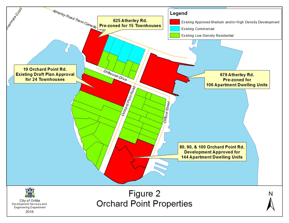
- Existing (or pre-zoned) medium and/or high density residential and/or commercial prior to 2010. (Approximately 33% of the land on Orchard Point was pre-zoned for medium and high density development.)
Given the relatively high percentage of lands pre-zoned for medium- and high-density residential development, the consultant recommended that Orchard Point be identified as an intensification area in the city’s Official Plan which was adopted by council on March 9, 2010.
Had Orchard Point been zoned and developed only for low-density residential, then the planning consultant likely would not have recommended Orchard Point be included in the city’s intensification area “save and except for the lands immediately abutting Highway 12.”
“I fully understand the report and the rationale of how we got where we are (and) why the change was made,” said Coun. Ted Emond.
However, he said he “has some sympathy” for the residents who “for whatever reason were not informed or did not take advantage of the opportunity to become informed about the designation. When they found out ... they became quite upset about it.”
With that in mind, Emond asked – and received his colleagues’ support – to have the area (with the exception of lands and frontage along Atherley Road and Highway 12) be considered for designation as a stable neighbourhood as part of the city’s next Official Plan review and update.
“I understand that’s a challenge in terms of a withdrawal of intensification and how we would have to convince the province and others that we’ve found alternative ways of meeting the increasing demand of provincial legislation for intensification in our community, but I do believe it's worth … taking a look,” said Emond.
While amenable to revisiting the issue, Coun. Tim Lauer said changing the zoning could have an unwanted ripple effect.
“If we were to take away the intensification area of Orchard Point, we would have to find another stable neighbourhood to add to our inventory to make up for that,” said Lauer. “That’s a bit scary to anyone who lives in a stable neighbourhood.”
He asked if it might be better to consider other forms of intensification, such as permitting taller buildings that would allow more people to live on a smaller footprint.
Ian Sugden, the city’s director of development services, conceded that is an option.
“The city’s Official Plan tries to achieve a range of housing types,” he explained. “We need to set aside enough land to accommodate a residential population of 46,000 people as allocated in the growth plan. There are a bunch of things we have to do in planning to balance the community.”
And while vertical development is an option, he issued a caution. “My experience in Orillia is Orillia is quite sensitive to building height, so it shouldn’t be our primary solution; it is one of the solutions.”
Sugden also defended the process leading up to the Orchard Point designation several years ago and the claim that residents were unaware of the change.
“I have been doing this business for almost 30 years and I’ve heard over all those 30 years people never knew something was happening,” said Sugden, who noted the Planning Act mandates public consultation and prescribes minimum standards. He said the city went above those minimum standards.
“During the formulation of the last Official Plan we had dozens of public consultation meetings ... over about four years. Planning is a two-way street: The public must become engaged and we must invite them to become engaged and they must participate. Try as we must, sometimes people feel they haven’t had an opportunity to learn about it or an opportunity to participate,” said Sugden. “We are always looking for new ways to improve and would try to do that in the future.”